Recent Blue Posts
 Hunter adjustments -- April 23
 Crests in Season 4
 Dragonflight Season 4 Content Update Notes
 MMO-Champion


Nope, all the blame will be put on Trump, especially if his admin screws this up because FEMA is short staffed.Originally Posted by Boole

 Recent Forum Posts
-
2017-08-24, 05:43 PM #21Scarab Lord

- Join Date
- Sep 2010
- Posts
- 4,501
-
2017-08-24, 05:43 PM #22Pit Lord

- Join Date
- Feb 2010
- Location
- Mobile, AL
- Posts
- 2,396
Seriously, go fuck yourself. I have friends in Houston, and family in Corpus Christi. this shit isn't a joke, especially if it hits Cat 3. Originally Posted by tonic316
-
2017-08-24, 05:43 PM #23The Undying


- Join Date
- Aug 2008
- Location
- Rigging your election
- Posts
- 36,856
It's funny when people confuse Bush's extremely poor handling of the nation's RESPONSE to a hurricane, and the hurricane itself. Originally Posted by Boole
But then again, we have people like Alex Jones who actually claimed that Obama changed the course of a hurricane to cancel an RNC.
There will be plenty of blame to lay at Trump's feet when he handles this even worse than Bush did.2014 Gamergate: "If you want games without hyper sexualized female characters and representation, then learn to code!"
2023: "What's with all these massively successful games with ugly (realistic) women? How could this have happened?!"
-
2017-08-24, 05:47 PM #24Field Marshal
- Join Date
- Jan 2014
- Posts
- 75
FTFY Originally Posted by Butter Emails
10 char
-
2017-08-24, 06:10 PM #25Scarab Lord
- Join Date
- Sep 2010
- Posts
- 4,501
1 pm CDT advsiory
- - - Updated - - -000
WTNT34 KNHC 241747
TCPAT4
BULLETIN
Hurricane Harvey Special Advisory Number 17
NWS National Hurricane Center Miami FL AL092017
100 PM CDT Thu Aug 24 2017
...HARVEY RAPIDLY INTENSIFYING...
...PREPARATIONS ALONG THE MIDDLE TEXAS COAST SHOULD BE RUSHED TO
COMPLETION TODAY...
SUMMARY OF 100 PM CDT...1800 UTC...INFORMATION
----------------------------------------------
LOCATION...24.4N 93.6W
ABOUT 335 MI...540 KM SE OF CORPUS CHRISTI TEXAS
ABOUT 325 MI...525 KM SSE OF PORT OCONNOR TEXAS
MAXIMUM SUSTAINED WINDS...85 MPH...140 KM/H
PRESENT MOVEMENT...NNW OR 335 DEGREES AT 10 MPH...17 KM/H
MINIMUM CENTRAL PRESSURE...979 MB...28.91 INCHES
WATCHES AND WARNINGS
--------------------
CHANGES WITH THIS ADVISORY:
None.
SUMMARY OF WATCHES AND WARNINGS IN EFFECT:
A Storm Surge Warning is in effect for...
* Port Mansfield to San Luis Pass Texas
A Storm Surge Watch is in effect for...
* South of Port Mansfield Texas to the Mouth of the Rio Grande
* North of San Luis Pass to High Island Texas
A Hurricane Warning is in effect for...
* Port Mansfield to Matagorda Texas
A Tropical Storm Warning is in effect for...
* North of Matagorda to High Island Texas
* South of Port Mansfield Texas to the Mouth of the Rio Grande
A Hurricane Watch is in effect for...
* South of Port Mansfield Texas to the Mouth of the Rio Grande
A Tropical Storm Watch is in effect for...
* South of the Mouth of the Rio Grande to Boca de Catan Mexico
A Storm Surge Warning means there is a danger of life-threatening
inundation, from rising water moving inland from the coastline,
during the next 36 hours in the indicated locations. For a
depiction of areas at risk, please see the National Weather
Service Storm Surge Watch/Warning Graphic, available at
hurricanes.gov. This is a life-threatening situation. Persons
located within these areas should take all necessary actions to
protect life and property from rising water and the potential for
other dangerous conditions. Promptly follow evacuation and other
instructions from local officials.
A Hurricane Warning means that hurricane conditions are expected
somewhere within the warning area. A warning is typically issued
36 hours before the anticipated first occurrence of tropical-storm-
force winds, conditions that make outside preparations difficult or
dangerous. Preparations to protect life and property should be
rushed to completion.
A Tropical Storm Warning means that tropical storm conditions are
expected somewhere within the warning area within 36 hours.
A Storm Surge Watch means there is a possibility of life-
threatening inundation, from rising water moving inland from the
coastline, in the indicated locations during the next 48 hours.
A Hurricane Watch means that hurricane conditions are possible
within the watch area.
A Tropical Storm Watch means that tropical storm conditions are
possible within the watch area.
In addition, interests in southwestern Louisiana should continue to
monitor the progress of this system.
For storm information specific to your area in the United States,
including possible inland watches and warnings, please monitor
products issued by your local National Weather Service forecast
office. For storm information specific to your area outside the
United States, please monitor products issued by your national
meteorological service.
DISCUSSION AND 48-HOUR OUTLOOK
------------------------------
At 100 PM CDT (1800 UTC), the eye of Hurricane Harvey was located
by reconnaissance aircraft near latitude 24.4 North, longitude 93.6
West. Harvey is moving toward the north-northwest near 10 mph (17
km/h). A turn toward the northwest is expected later today, and
Harvey's forward speed is forecast to slow down during the next
couple of days. On the forecast track, Harvey will approach the
middle Texas coast on Friday and make landfall Friday night or early
Saturday, and then stall near the middle Texas coast through the
weekend.
Data from Air Force Reserve and NOAA Hurricane Hunter aircraft
indicate that maximum sustained winds have increased to near 85 mph
(140 km/h) with higher gusts. Additional rapid strengthening is
forecast, and Harvey is expected to become a major hurricane by
Friday before it reaches the middle Texas coast.
Hurricane-force winds extend outward up to 25 miles (35 km) from the
center, and tropical-storm-force winds extend outward up to 90 miles
(150 km).
Data from the NOAA Hurricane Hunter plane indicate that the minimum
central pressure is 979 mb (28.91 inches).
HAZARDS AFFECTING LAND
----------------------
RAINFALL: Harvey is expected to produce total rain accumulations of
12 to 20 inches and isolated maximum amounts of 30 inches over the
middle and upper Texas coast through next Wednesday. During the same
time period Harvey is expected to produce total rain accumulations
of 5 to 12 inches in far south Texas and the Texas Hill Country to
central Louisiana, with accumulations of less than 5 inches
extending into other parts of Texas and the lower Mississippi
Valley. Rainfall from Harvey may cause life-threatening flooding.
STORM SURGE: The combination of a dangerous storm surge and the
tide will cause normally dry areas near the coast to be flooded by
rising waters moving inland from the shoreline. The water is
expected to reach the following heights above ground if the peak
surge occurs at the time of high tide...
N Entrance Padre Island Natl Seashore to Sargent...6 to 12 ft
Sargent to Jamaica Beach...5 to 8 ft
Port Mansfield to N Entrance Padre Island Natl Seashore...5 to 7 ft
Jamaica Beach to High Island...2 to 4 ft
Mouth of the Rio Grande to Port Mansfield...2 to 4 ft
High Island to Morgan City...1 to 3 ft
The deepest water will occur along the immediate coast near and to
the northeast of the landfall location, where the surge will be
accompanied by large and destructive waves. Surge-related flooding
depends on the relative timing of the surge and the tidal cycle, and
can vary greatly over short distances. For information specific to
your area, please see products issued by your local National Weather
Service forecast office.
WIND: Hurricane conditions are likely within the hurricane warning
area late Friday or Friday night, with tropical storm conditions
expected to first reach the coast in the hurricane warning area
Friday.
SURF: Swells generated by Harvey are likely to affect the Texas,
Louisiana, and northeast Mexico coasts by Friday. These swells are
likely to cause life-threatening surf and rip current conditions.
Please consult products from your local weather office.
NEXT ADVISORY
-------------
Next complete advisory at 400 PM CDT.
$$
Forecaster Berg
They're expecting a strong Category 3 before landfall.
- - - Updated - - -
/10characters000
WTNT44 KNHC 241748
TCDAT4
Hurricane Harvey Special Discussion Number 17
NWS National Hurricane Center Miami FL AL092017
100 PM CDT Thu Aug 24 2017
This special advisory is being issued to update Harvey's initial
and forecast intensities through the 48-hour period. The storm
surge values in the public advisory have also been updated based on
the new intensity forecast.
Recent data from Air Force Reserve and NOAA Hurricane Hunter
aircraft indicate that Harvey's maximum sustained winds have
increased to 75 kt. The Air Force plane measured maximum 850-mb
flight-level winds of 88 kt and reliable SFMR winds around 75 kt.
Based on the hurricane's current rate of intensification, the
forecast intensities at 12 and 24 h have been raised by 15 kt,
with a 10-kt increase at 36 h. There are no changes to the track or
wind radii forecast with this special advisory.
It is critical that users not focus on the exact forecast track
of Harvey, since cycle-to-cycle adjustment are likely. All
locations within the hurricane and storm surge warning areas should
be preparing for the possibility of major hurricane-force winds and
life-threatening storm surge.
Note that this special advisory takes the place of the scheduled
100 PM CDT (1800 UTC) intermediate advisory.
Key Messages:
1. Harvey has intensified rapidly, and is forecast to be a major
hurricane at landfall, bringing life-threatening storm surge,
rainfall, and wind hazards to portions of the Texas coast.
Preparations to protect life and property should be completed by
tonight, as tropical-storm-force winds will first arrive in the
hurricane and storm surge warning areas on Friday.
2. A Storm Surge Warning is in effect for much of the Texas coast.
Life-threatening storm surge flooding could reach heights of 6 to 12
feet above ground level at the coast between the north entrance of
the Padre Island National Seashore and Sargent. For a depiction of
areas at risk, see the Storm Surge Watch/Warning Graphic at
hurricanes.gov.
3. Life-threatening flooding is expected across much of the Texas
coast from heavy rainfall of 12 to 20 inches, with isolated amounts
as high as 30 inches, from Friday through early next week. Please
refer to products from your local National Weather Service office
and the NOAA Weather Prediction Center for more information on the
flooding hazard.
4. The Potential Storm Surge Flooding Map is available on the NHC
website. This product depicts a reasonable worst-case scenario -
the amount of inundation that has a 10 percent chance of being
exceeded at each individual location. This map best represents
the flooding potential in those locations within the watch and
warning areas.
FORECAST POSITIONS AND MAX WINDS
INIT 24/1800Z 24.4N 93.6W 75 KT 85 MPH
12H 25/0000Z 24.9N 94.2W 85 KT 100 MPH
24H 25/1200Z 26.0N 95.3W 105 KT 120 MPH
36H 26/0000Z 27.3N 96.3W 110 KT 125 MPH
48H 26/1200Z 28.3N 97.0W 100 KT 115 MPH...INLAND
72H 27/1200Z 29.0N 97.7W 40 KT 45 MPH...INLAND
96H 28/1200Z 28.5N 97.5W 35 KT 40 MPH...INLAND
120H 29/1200Z 28.5N 96.5W 30 KT 35 MPH...INLAND
$$
Forecaster Berg
- - - Updated - - -

-
2017-08-24, 06:14 PM #26Mechagnome

- Join Date
- Jul 2015
- Location
- Canada
- Posts
- 652
... i doubt your going to be watching the fight.... goodluck, srsly - sounds like this could be a major storm Originally Posted by Dug
-
2017-08-24, 06:18 PM #27Legendary!
- Join Date
- Apr 2008
- Posts
- 6,513
IF? What do you mean IF? Originally Posted by johnhoftb
His entire administration is a fucking nightmare of crippling ineffectiveness at this point. This thing is going to be a trainwreck of legendary proportions if even the bare minimum of national government response is required.
-
2017-08-24, 06:18 PM #28The Insane

- Join Date
- Jul 2013
- Location
- Texas
- Posts
- 15,636
Thanks. Probably will do some damage as they always do but if it keeps on its trajectory I'm south of the center so we'll get some heavy rain but the wind shouldn't be too bad. Originally Posted by Gravity2015
-
2017-08-25, 12:04 AM #29Scarab Lord
- Join Date
- Sep 2010
- Posts
- 4,501
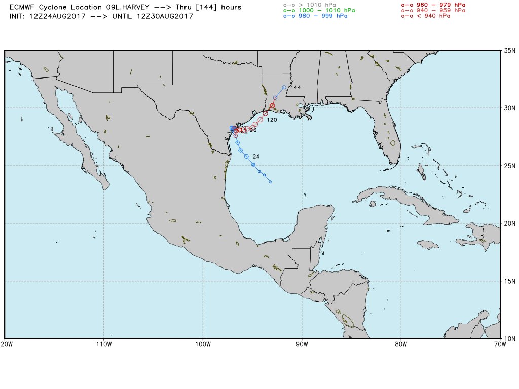
Here's some random useless information.
Twitter did not exist the last time a category 3 hurricane hit the US.
Or in WoW terms, the last patch (1.12.2) of vanilla WoW was only a couple of weeks old
- - - Updated - - -
Also, worst case scenario predicted by EURO models:
- - - Updated - - -
000 WTNT34 KNHC 242045 TCPAT4 BULLETIN Hurricane Harvey Advisory Number 18 NWS National Hurricane Center Miami FL AL092017 400 PM CDT Thu Aug 24 2017 ...HARVEY HEADED TOWARD THE TEXAS COAST... ...LIFE-THREATENING AND DEVASTATING FLOODING EXPECTED NEAR THE COAST DUE TO HEAVY RAINFALL AND STORM SURGE... SUMMARY OF 400 PM CDT...2100 UTC...INFORMATION ---------------------------------------------- LOCATION...24.7N 93.9W ABOUT 305 MI...490 KM SE OF CORPUS CHRISTI TEXAS ABOUT 300 MI...480 KM SSE OF PORT OCONNOR TEXAS MAXIMUM SUSTAINED WINDS...85 MPH...140 KM/H PRESENT MOVEMENT...NNW OR 330 DEGREES AT 10 MPH...17 KM/H MINIMUM CENTRAL PRESSURE...976 MB...28.82 INCHES WATCHES AND WARNINGS -------------------- CHANGES WITH THIS ADVISORY: The Hurricane Warning has been extended northeast of Matagorda to Sargent Texas. SUMMARY OF WATCHES AND WARNINGS IN EFFECT: A Storm Surge Warning is in effect for... * Port Mansfield to High Island Texas A Storm Surge Watch is in effect for... * South of Port Mansfield Texas to the Mouth of the Rio Grande A Hurricane Warning is in effect for... * Port Mansfield to Sargent Texas A Tropical Storm Warning is in effect for... * North of Sargent to High Island Texas * South of Port Mansfield Texas to the Mouth of the Rio Grande A Hurricane Watch is in effect for... * South of Port Mansfield Texas to the Mouth of the Rio Grande A Tropical Storm Watch is in effect for... * South of the Mouth of the Rio Grande to Boca de Catan Mexico A Storm Surge Warning means there is a danger of life-threatening inundation, from rising water moving inland from the coastline, during the next 36 hours in the indicated locations. For a depiction of areas at risk, please see the National Weather Service Storm Surge Watch/Warning Graphic, available at hurricanes.gov. This is a life-threatening situation. Persons located within these areas should take all necessary actions to protect life and property from rising water and the potential for other dangerous conditions. Promptly follow evacuation and other instructions from local officials. A Hurricane Warning means that hurricane conditions are expected somewhere within the warning area. A warning is typically issued 36 hours before the anticipated first occurrence of tropical-storm- force winds, conditions that make outside preparations difficult or dangerous. Preparations to protect life and property should be rushed to completion. A Storm Surge Watch means there is a possibility of life- threatening inundation, from rising water moving inland from the coastline, in the indicated locations during the next 48 hours. A Hurricane Watch means that hurricane conditions are possible within the watch area. In addition, interests in southwestern Louisiana should continue to monitor the progress of this system. For storm information specific to your area in the United States, including possible inland watches and warnings, please monitor products issued by your local National Weather Service forecast office. For storm information specific to your area outside the United States, please monitor products issued by your national meteorological service. DISCUSSION AND 48-HOUR OUTLOOK ------------------------------ At 400 PM CDT (2100 UTC), the eye of Hurricane Harvey was located near latitude 24.7 North, longitude 93.9 West. Harvey is moving toward the north-northwest near 10 mph (17 km/h). A turn toward the northwest is expected this evening, and Harvey's forward speed is forecast to slow down during the next couple of days. On the forecast track, Harvey will approach the middle Texas coast on Friday and make landfall Friday night or early Saturday. Harvey is then likely to stall near or just inland of the middle Texas coast through the weekend. Maximum sustained winds are near 85 mph (140 km/h) with higher gusts. Strengthening is forecast, and Harvey is expected to become a major hurricane by Friday before it reaches the middle Texas coast. Hurricane-force winds extend outward up to 25 miles (35 km) from the center, and tropical-storm-force winds extend outward up to 90 miles (150 km). The minimum central pressure based on dropsonde data released by a NOAA Hurricane Hunter aircraft is 976 mb (28.82 inches). HAZARDS AFFECTING LAND ---------------------- RAINFALL: Harvey is expected to produce total rain accumulations of 15 to 25 inches and isolated maximum amounts of 35 inches over the middle and upper Texas coast through next Wednesday. During the same time period Harvey is expected to produce total rain accumulations of 7 to 15 inches in far south Texas and the Texas Hill Country over through central and southwest Louisiana, with accumulations of up to 7 inches extending into other parts of Texas and the lower Mississippi Valley. Rainfall from Harvey may cause devastating and life-threatening flooding. STORM SURGE: The combination of a dangerous storm surge and the tide will cause normally dry areas near the coast to be flooded by rising waters moving inland from the shoreline. The water is expected to reach the following heights above ground if the peak surge occurs at the time of high tide... N Entrance Padre Island Natl Seashore to Sargent...6 to 12 ft Sargent to Jamaica Beach...5 to 8 ft Port Mansfield to N Entrance Padre Island Natl Seashore...5 to 7 ft Jamaica Beach to High Island...2 to 4 ft Mouth of the Rio Grande to Port Mansfield...2 to 4 ft High Island to Morgan City...1 to 3 ft The deepest water will occur along the immediate coast near and to the northeast of the landfall location, where the surge will be accompanied by large and destructive waves. Surge-related flooding depends on the relative timing of the surge and the tidal cycle, and can vary greatly over short distances. For information specific to your area, please see products issued by your local National Weather Service forecast office. WIND: Hurricane conditions are likely within the hurricane warning area late Friday or Friday night, with tropical storm conditions expected to first reach the coast in the hurricane warning area Friday. SURF: Swells generated by Harvey are likely to affect the Texas, Louisiana, and northeast Mexico coasts by Friday. These swells are likely to cause life-threatening surf and rip current conditions. Please consult products from your local weather office. NEXT ADVISORY ------------- Next intermediate advisory at 700 PM CDT. Next complete advisory at 1000 PM CDT. $$ Forecaster Berg
- - - Updated - - -
7 pm CDT intermediate advisory.
Also, sorry for the issue with syntax. On phone.
ZCZC MIATCPAT4 ALL TTAA00 KNHC DDHHMM BULLETIN Hurricane Harvey Intermediate Advisory Number 18A NWS National Hurricane Center Miami FL AL092017 700 PM CDT Thu Aug 24 2017 ...HARVEY MOVING NORTHWESTWARD TOWARD THE TEXAS COAST... ...LIFE-THREATENING AND DEVASTATING FLOODING EXPECTED NEAR THE COAST DUE TO HEAVY RAINFALL AND STORM SURGE... SUMMARY OF 700 PM CDT...0000 UTC...INFORMATION ---------------------------------------------- LOCATION...25.0N 94.3W ABOUT 275 MI...445 KM SE OF CORPUS CHRISTI TEXAS ABOUT 270 MI...435 KM SSE OF PORT OCONNOR TEXAS MAXIMUM SUSTAINED WINDS...85 MPH...140 KM/H PRESENT MOVEMENT...NW OR 325 DEGREES AT 10 MPH...17 KM/H MINIMUM CENTRAL PRESSURE...974 MB...28.76 INCHES WATCHES AND WARNINGS -------------------- CHANGES WITH THIS ADVISORY: None. SUMMARY OF WATCHES AND WARNINGS IN EFFECT: A Storm Surge Warning is in effect for... * Port Mansfield to High Island Texas A Storm Surge Watch is in effect for... * South of Port Mansfield Texas to the Mouth of the Rio Grande A Hurricane Warning is in effect for... * Port Mansfield to Sargent Texas A Tropical Storm Warning is in effect for... * North of Sargent to High Island Texas * South of Port Mansfield Texas to the Mouth of the Rio Grande A Hurricane Watch is in effect for... * South of Port Mansfield Texas to the Mouth of the Rio Grande A Tropical Storm Watch is in effect for... * South of the Mouth of the Rio Grande to Boca de Catan Mexico A Storm Surge Warning means there is a danger of life-threatening inundation, from rising water moving inland from the coastline, during the next 36 hours in the indicated locations. For a depiction of areas at risk, please see the National Weather Service Storm Surge Watch/Warning Graphic, available at hurricanes.gov. This is a life-threatening situation. Persons located within these areas should take all necessary actions to protect life and property from rising water and the potential for other dangerous conditions. Promptly follow evacuation and other instructions from local officials. A Hurricane Warning means that hurricane conditions are expected somewhere within the warning area. A warning is typically issued 36 hours before the anticipated first occurrence of tropical-storm- force winds, conditions that make outside preparations difficult or dangerous. Preparations to protect life and property should be rushed to completion. A Storm Surge Watch means there is a possibility of life- threatening inundation, from rising water moving inland from the coastline, in the indicated locations during the next 48 hours. A Hurricane Watch means that hurricane conditions are possible within the watch area. In addition, interests in southwestern Louisiana should continue to monitor the progress of this system. For storm information specific to your area in the United States, including possible inland watches and warnings, please monitor products issued by your local National Weather Service forecast office. For storm information specific to your area outside the United States, please monitor products issued by your national meteorological service. DISCUSSION AND 48-HOUR OUTLOOK ------------------------------ At 700 PM CDT (0000 UTC), the eye of Hurricane Harvey was located near latitude 25.0 North, longitude 94.3 West. Harvey is moving toward the northwest near 10 mph (17 km/h). This general motion is expected to continue with a decrease in forward speed during the next couple of days. On the forecast track, Harvey will approach the middle Texas coast on Friday and make landfall Friday night or early Saturday. Harvey is then likely to stall near or just inland of the middle Texas coast through the weekend. Reports from an Air Force Reserve Hurricane Hunter aircraft indicate that maximum sustained winds remain near 85 mph (140 km/h) with higher gusts. While Harvey has changed little in strength over the past few hours, strengthening is expected to resume during the next few hours, and Harvey is expected to become a major hurricane by Friday before it reaches the middle Texas coast. Hurricane-force winds extend outward up to 25 miles (35 km) from the center, and tropical-storm-force winds extend outward up to 90 miles (150 km). The minimum central pressure just reported by the Hurricane Hunter Aircraft is 974 mb (28.76 inches). HAZARDS AFFECTING LAND ---------------------- RAINFALL: Harvey is expected to produce total rain accumulations of 15 to 25 inches and isolated maximum amounts of 35 inches over the middle and upper Texas coast through next Wednesday. During the same time period Harvey is expected to produce total rain accumulations of 7 to 15 inches in far south Texas and the Texas Hill Country over through central and southwest Louisiana, with accumulations of up to 7 inches extending into other parts of Texas and the lower Mississippi Valley. Rainfall from Harvey will cause devastating and life-threatening flooding. STORM SURGE: The combination of a dangerous storm surge and the tide will cause normally dry areas near the coast to be flooded by rising waters moving inland from the shoreline. The water is expected to reach the following heights above ground if the peak surge occurs at the time of high tide... N Entrance Padre Island Natl Seashore to Sargent...6 to 12 ft Sargent to Jamaica Beach...5 to 8 ft Port Mansfield to N Entrance Padre Island Natl Seashore...5 to 7 ft Jamaica Beach to High Island...2 to 4 ft Mouth of the Rio Grande to Port Mansfield...2 to 4 ft High Island to Morgan City...1 to 3 ft The deepest water will occur along the immediate coast near and to the northeast of the landfall location, where the surge will be accompanied by large and destructive waves. Surge-related flooding depends on the relative timing of the surge and the tidal cycle, and can vary greatly over short distances. For information specific to your area, please see products issued by your local National Weather Service forecast office. WIND: Hurricane conditions are likely within the hurricane warning area late Friday or Friday night, with tropical storm conditions expected to first reach the coast in the hurricane warning area Friday. SURF: Swells generated by Harvey are likely to affect the Texas, Louisiana, and northeast Mexico coasts by Friday. These swells are likely to cause life-threatening surf and rip current conditions. Please consult products from your local weather office. TORNADOES: Isolated tornadoes are possible across portions of the middle and upper Texas coast on Friday. NEXT ADVISORY ------------- Next complete advisory at 1000 PM CDT. $$ Forecaster Beven NNNN
-
2017-08-25, 01:01 AM #30Pandaren Monk

- Join Date
- Apr 2010
- Posts
- 1,751
This would explain why my younger brother isn't headed back to Galveston this weekend (he goes to college at A&M). I'm not overly worried about Houston, Galveston, or other coastal areas in TX. They can deal with hurricanes rather well.
Places like San Antonio can barely handle flooding. My grandma lives near Leon Valley, and once the local creek overflows. Most of northside is screwed over and shuts down for WEEKS. It's hard to get anywhere. I imagine my little sister is gonna go stir crazy. Same for my parents that live a few hours north of San Antonio.
Actually... I wouldn't be surprised if my dad is driving TOWARDS Corpus Christi (I was born there). He loves hurricanes. Was a meteorologist in the Navy. Used to live in Norfolk, VA. He was always sitting outside on the porch with a beer in hand during them. He never evacuated with us :P I wouldn't be surprised one day if he gets himself killed.
Texans see this crap differently anyway. At least where I'm from. It dry as hell this time year, and any rain is welcome. Sometimes nature gives a hurricane instead of thunderstorms.
-
2017-08-25, 01:01 AM #31Moderator

- Join Date
- Oct 2012
- Location
- The Moon
- Posts
- 32,145
Whelp, glad my sister is up here for 2 more weeks. She lives on the coast normally o.o


-
2017-08-25, 01:10 AM #32Titan

- Join Date
- Dec 2010
- Location
- Charleston SC
- Posts
- 13,870
Looks like it'll mostly be a rain event probably..... should be fine so long as no one trys to drive through a few feet of water...... so you know 5-10 deaths I'd guess.
Originally Posted by Connal
-
2017-08-25, 01:12 AM #33The Lightbringer

- Join Date
- Jan 2011
- Location
- California
- Posts
- 3,804
To those who are going to be in the direct path or have family living there be safe guys. If possible maybe find some other accommodations till the worst of the storm passes
 .
"It's time to kick ass and chew bubblegum... and I'm all outta ass."
.
"It's time to kick ass and chew bubblegum... and I'm all outta ass."
I'm a British gay Muslim Pakistani American citizen, ask me how that works! (terribly)
-
2017-08-25, 01:23 AM #34The Lightbringer

- Join Date
- Mar 2011
- Posts
- 3,831
Galveston TX got hit by a Cat 4 Hurricane in 1900
Between 6000 to 120000 people died. Worst Natural disaster in US History.
Galveston TX does not sound a good place to be for this one
https://en.wikipedia.org/wiki/1900_Galveston_hurricane

-
2017-08-25, 01:26 AM #35Void Lord

- Join Date
- Oct 2010
- Location
- NY, USA
- Posts
- 40,015
MMO-Cers in the targeted landfall area: please follow the directions given by federal and state safety and emergency officials, and either travel, or hide, safely.
Good luck.
-
2017-08-25, 01:56 AM #36Merely a Setback

- Join Date
- Jul 2010
- Location
- ██████
- Posts
- 26,366
Yes it did. FL had one last year (not directly, thankfully due to some final hour luck the eye stayed off the coast). It still did a number in the Carolina's. Originally Posted by johnhoftb
Unfortunately Gulf of Mexico storms are practically landlocked so theres no final hour changes of direction to keep it from making landfall.
Doubtful it will turn towards New Orleans but hurricanes get more unpredictable as the approach land it seems.
Hopefully everyone has prepared and it goes through swiftly (slow hurricanes are the worst because they can sustain themselves over warm water for longer periods of time).
- - - Updated - - -
Cat 3 arent just the fun rain ones but they shouldnt be deadly as long as you dont go outside or remain in flemsy buildings. The aftermath of them are the problem. Flooding, power outages, threes everywhere. We had 3 days without power and multiple large trees down (entire lawns uprooted) even though the thing just sat off the coast Originally Posted by Tierbook

Resident Cosplay Progressive
-
2017-08-25, 02:25 AM #37High Overlord
- Join Date
- Nov 2009
- Posts
- 139
As someone who went through Hurricane Andrew in Homestead Florida back in the 90's. thoughts and prayers go out to everyone in the TX coastal areas be safe.
-
2017-08-25, 02:39 AM #38The Insane

- Join Date
- Dec 2008
- Location
- Mostly harmless
- Posts
- 19,388
Why do bad things always happen to me? I swear I have the worst fucking luck this year. If Euro model happens..fuck my life. Euro's please for the love of everything be wrong.
Galvestion is an island, right next to the coast, that is why. Originally Posted by Aussiedude
Time...line? Time isn't made out of lines. It is made out of circles. That is why clocks are round. ~ Caboose
-
2017-08-25, 02:51 AM #39Scarab Lord
- Join Date
- Sep 2010
- Posts
- 4,501
10 pm CDT advisory.
- - - Updated - - -000
WTNT34 KNHC 250234
TCPAT4
BULLETIN
Hurricane Harvey Advisory Number 19
NWS National Hurricane Center Miami FL AL092017
1000 PM CDT Thu Aug 24 2017
...HARVEY EXPECTED TO STRENGTHEN AS IT MOVES TOWARDS THE TEXAS
COAST...
...LIFE-THREATENING AND DEVASTATING FLOODING EXPECTED NEAR THE
COAST DUE TO HEAVY RAINFALL AND STORM SURGE...
SUMMARY OF 1000 PM CDT...0300 UTC...INFORMATION
-----------------------------------------------
LOCATION...25.2N 94.6W
ABOUT 250 MI...400 KM SE OF CORPUS CHRISTI TEXAS
ABOUT 245 MI...400 KM SSE OF PORT OCONNOR TEXAS
MAXIMUM SUSTAINED WINDS...85 MPH...140 KM/H
PRESENT MOVEMENT...NW OR 315 DEGREES AT 10 MPH...17 KM/H
MINIMUM CENTRAL PRESSURE...973 MB...28.74 INCHES
WATCHES AND WARNINGS
--------------------
CHANGES WITH THIS ADVISORY:
None.
SUMMARY OF WATCHES AND WARNINGS IN EFFECT:
A Storm Surge Warning is in effect for...
* Port Mansfield to High Island Texas
A Storm Surge Watch is in effect for...
* South of Port Mansfield Texas to the Mouth of the Rio Grande
A Hurricane Warning is in effect for...
* Port Mansfield to Sargent Texas
A Tropical Storm Warning is in effect for...
* North of Sargent to High Island Texas
* South of Port Mansfield Texas to the Mouth of the Rio Grande
A Hurricane Watch is in effect for...
* South of Port Mansfield Texas to the Mouth of the Rio Grande
A Tropical Storm Watch is in effect for...
* South of the Mouth of the Rio Grande to Boca de Catan Mexico
A Storm Surge Warning means there is a danger of life-threatening
inundation, from rising water moving inland from the coastline,
during the next 36 hours in the indicated locations. For a depiction
of areas at risk, please see the National Weather Service Storm
Surge Watch/Warning Graphic, available at hurricanes.gov. This is a
life-threatening situation. Persons located within these areas
should take all necessary actions to protect life and property from
rising water and the potential for other dangerous conditions.
Promptly follow evacuation and other instructions from local
officials.
A Hurricane Warning means that hurricane conditions are expected
somewhere within the warning area. A warning is typically issued
36 hours before the anticipated first occurrence of tropical-storm-
force winds, conditions that make outside preparations difficult or
dangerous. Preparations to protect life and property should be
rushed to completion.
A Storm Surge Watch means there is a possibility of life-
threatening inundation, from rising water moving inland from the
coastline, in the indicated locations during the next 48 hours.
A Hurricane Watch means that hurricane conditions are possible
within the watch area.
In addition, interests in southwestern Louisiana should continue to
monitor the progress of this system.
For storm information specific to your area in the United
States, including possible inland watches and warnings, please
monitor products issued by your local National Weather Service
forecast office. For storm information specific to your area outside
the United States, please monitor products issued by your national
meteorological service.
DISCUSSION AND 48-HOUR OUTLOOK
------------------------------
At 1000 PM CDT (0300 UTC), the center of Hurricane Harvey was
located near latitude 25.2 North, longitude 94.6 West. Harvey is
moving toward the northwest near 10 mph (17 km/h). This general
motion is expected to continue with a decrease in forward speed
during the next couple of days. On the forecast track, Harvey will
approach the middle Texas coast on Friday and make landfall Friday
night or early Saturday. Harvey is then likely to stall near or
just inland of the middle Texas coast through the weekend.
Reports from an Air Force Reserve Hurricane Hunter aircraft
indicate that maximum sustained winds remain near 85 mph (140 km/h)
with higher gusts. While Harvey has changed little in strength over
the past several hours, strengthening is expected to resume later
tonight, and Harvey is expected to become a major hurricane by
Friday before it reaches the middle Texas coast.
Hurricane-force winds extend outward up to 25 miles (35 km) from the
center and tropical-storm-force winds extend outward up to 105 miles
(165 km).
The latest minimum central pressure reported by the Hurricane
Hunter aircraft is 973 mb (28.74 inches).
HAZARDS AFFECTING LAND
----------------------
RAINFALL: Harvey is expected to produce total rain accumulations
of 15 to 25 inches and isolated maximum amounts of 35 inches over
the middle and upper Texas coast through next Wednesday. During
the same time period Harvey is expected to produce total rain
accumulations of 7 to 15 inches in far south Texas and the Texas
Hill Country eastward through central and southwest Louisiana, with
accumulations of up to 7 inches extending into other parts of Texas
and the lower Mississippi Valley. Rainfall from Harvey will cause
devastating and life-threatening flooding.
STORM SURGE: The combination of a dangerous storm surge and the
tide will cause normally dry areas near the coast to be flooded by
rising waters moving inland from the shoreline. The water is
expected to reach the following heights above ground if the peak
surge occurs at the time of high tide...
N Entrance Padre Island Natl Seashore to Sargent...6 to 12 ft
Sargent to Jamaica Beach...5 to 8 ft
Port Mansfield to N Entrance Padre Island Natl Seashore...5 to 7 ft
Jamaica Beach to High Island...2 to 4 ft
Mouth of the Rio Grande to Port Mansfield...2 to 4 ft
High Island to Morgan City...1 to 3 ft
The deepest water will occur along the immediate coast near and to
the northeast of the landfall location, where the surge will be
accompanied by large and destructive waves. Surge-related flooding
depends on the relative timing of the surge and the tidal cycle, and
can vary greatly over short distances. For information specific to
your area, please see products issued by your local National Weather
Service forecast office.
WIND: Hurricane conditions are likely within the hurricane warning
area late Friday and Friday night, with tropical storm conditions
expected to first reach the coast in the hurricane warning area
Friday. These conditions are likely to persist into Saturday in
portions of the hurricane and tropical storm warning area.
SURF: Swells generated by Harvey are likely to affect the Texas,
Louisiana, and northeast Mexico coasts by Friday. These swells are
likely to cause life-threatening surf and rip current conditions.
Please consult products from your local weather office.
TORNADOES: Isolated tornadoes are possible across portions of the
middle and upper Texas coast on Friday.
NEXT ADVISORY
-------------
Next intermediate advisories at 1200 AM CDT and 200 AM CDT.
Next complete advisory at 400 AM CDT.
$$
Forecaster Beven

Last edited by johnhoftb; 2017-08-25 at 04:03 AM.
-
2017-08-25, 04:04 AM #40Elemental Lord
- Join Date
- Aug 2015
- Posts
- 8,711
Building standard has changed since then. Wind is not my area of specialty, but I assume buildings in Galveston are designed based on 150 mph basic wind speed. Maybe even 170 mph like Guam. Originally Posted by Aussiedude

 Reply With Quote