Yet another Timewalking loot post ( As directed by GM)
 Opened timewalking Cache before hotfix
 Did Blizzard just hotfix an ilvl requirement onto Awakened LFR?
 The WoW Companion App is Retiring
 Best way to farm Tusks of Mannoroth?
 MMO-Champion


Imagine making an investment decision based on intelligence gathered from a satellite or drone image. James Crawford is betting people will do exactly that.
The founder and CEO of Orbital Images saw an untapped potential in the increase of surveillance hardware and decided to create software to analyze the images.
With the world of drones on the rise—federal regulators expect the industry to expand into a $90 billion business, compared to an estimated $720 million in sales last year—Orbital's goal is to capture global socioeconomic trends and sell it to hedge funds, real estate developers and other organizations.
For its part, Orbital insists its technology shouldn't raise alarm bells. While some may be concerned about Big Brother watching from above, Crawford said there are limits on the image's resolution and individuals cannot be seen.
"We can count cars, but even when we count cars we can't tell one car from another. The imagery itself and the federal limits on imagery put a major barrier to any sort of privacy issues," he said. http://www.cnbc.com/id/102519682
I wonder how long before the "limits" are no longer there? It's only a matter of time. Satellites watching you from space, ahh the future. So we have cameras on the streets, microphones and now satellites watching us. It's like 1984 coming to fruition.
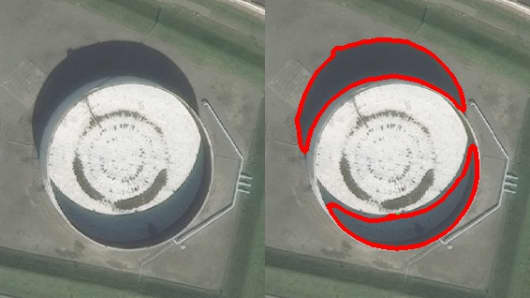
Shadow detection shows global oil inventory.
 Recent Blue Posts
 Recent Forum Posts
-
2015-03-22, 02:43 AM #1Banned


- Join Date
- Mar 2012
- Posts
- 22,007
I spy...then sell the data: Orbital's bet on satellites and drones.
-
2015-03-22, 02:54 AM #2The Patient
- Join Date
- Nov 2011
- Posts
- 281
Individuals cannot be seen yet. Originally Posted by lockedout

Anything can be harmful when taken to an extreme. Even moderation.
-
2015-03-22, 03:00 AM #3Legendary!

- Join Date
- Nov 2013
- Posts
- 6,178
Move into the woods and build an underground bunker you say? Well, don't mind if I do.
-
2015-03-22, 03:26 AM #4The Undying

- Join Date
- Apr 2014
- Location
- Nevada
- Posts
- 33,542
They take photos of corn and soybean fields to see if the crops are suffering drought or disease. You could probably use information like that to buy and sell corn and soybean futures on the market.
.
"This will be a fight against overwhelming odds from which survival cannot be expected. We will do what damage we can."
-- Capt. Copeland
-
2015-03-22, 03:31 AM #5Legendary!

- Join Date
- Apr 2013
- Posts
- 6,385
How about orange juice? Originally Posted by Hubcap
Looking good Billy Ray!MAGA
When all you do is WIN WIN WIN
-
2015-03-22, 03:46 AM #6Moderator

- Join Date
- Oct 2012
- Location
- The Moon
- Posts
- 32,145
As someone that uses software that relies on images, let me tell you they can already gleam a LOT if information already and map it. This isn't too new, as satellite tech will only improve further that will allow for more detailed images to be catagorized. The info is already being used too by companies and governments alike.


-
2015-03-22, 05:41 AM #7Merely a Setback

- Join Date
- Aug 2010
- Location
- In the state of Denial.
- Posts
- 27,129
I use satellite information and imagery in Google every day to do my job. There is no expectation of privacy outdoors.
Human progress isn't measured by industry. It's measured by the value you place on a life.
Just, be kind.
-
2015-03-22, 06:18 AM #8The Lightbringer

- Join Date
- Jan 2012
- Posts
- 3,681
I need to start investing in huge tents / tarps / canopies that block satellite and drone imaging.

 Reply With Quote