Limited PvP -> PvE Free Character Transfers
 Mythic+ Dungeon Adjustments - 27 April
 This Week in WoW - April 26, 2024
 MMO-Champion


I wonder if US Army personal will soon be told not to use fitness devices like Fitbits etc ?
Just shows that the Military really need to be up to date with what Modern mainstream Technology can potentially do.
It was good that this alert was found by a US Ally like Australia & not an enemy during a conflict situation.
Otherwise an enemy Air Force could find and attack the bases.
http://www.abc.net.au/news/science/2...routes/9369490
https://www.washingtonpost.com/world...=.955b0e3aa47c
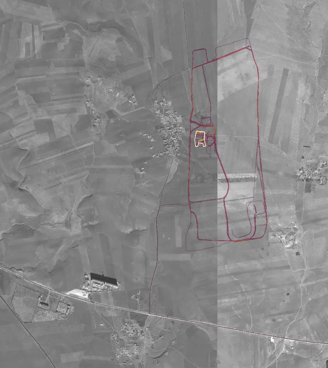
Strava, a fitness-tracking app, is revealing potentially sensitive information about military bases and supply routes via its global heatmap website.
The data map shows 1 billion activities and 3 trillion points of latitude and longitude from "Strava's global network of athletes", according to the American company.
On the weekend, 20-year-old Australian university student Nathan Ruser noticed the map showed the locations and running routines of military personnel at bases in the Middle East and other conflict zones.
Speaking from Thailand, Mr Ruser, who is studying international security at the Australian National University, said he had been following the situation in Syria since 2014.
When he came across Strava's heatmap, he decided to look at the war-torn region and said "the whole thing lit up like a Christmas tree."
When you look at Strava's heatmap in countries like Australia, you see a lot of "noise" from civilians using the app. Sydney, for example, glows gold with people's jogging habits.
That's not the case in the Middle East or Africa, where lone activities stand out against an all-black background.
"In countries where that is not so much a thing, that noise gets filtered out," Mr Ruser said.
"The only people using the apps would be foreign military personnel."
According to the Washington Post, the US military is looking into the situation.
Strava activity around Al Asad airbase in Iraq, where Australian soldiers have trained local forces.
Strava collects data from phones and fitness trackers such as Fitbit, and allows users to share their routine with friends and followers. Its aggregated heatmap shows information collected between 2015 and September 2017.
While security analysts often use satellite imagery to study military installations, Mr Ruser said the Strava data added an additional, possibly dangerous layer of information.
Using satellite imagery, you can see base buildings, for example. But on the heatmap, you can see which buildings are most used, or the jogging routes of soldiers.
Danielle Cave, a senior analyst at the International Cyber Policy Centre at the Australian Strategic Policy Institute, called the heatmap an "open source intelligence gold mine".
She suggested the data also raised a cyber security risk.
"A hacking group, state or non-state, could very easily now target Strava knowing how valuable the data is that they are holding," she said.
"If it does turn out that people can strip out the personal details of some of these Strava users, then I think it's getting into a very dangerous place."
A Strava spokesperson said the heatmap represented "an aggregated and anonymized view" of its users activities.
He added that Strava allows users to create a "privacy zone" — a tool that obscures activity within a pre-selected radius.
Mr Ruser doesn't think the situation is all Strava's fault.
"They probably should have had the foresight to look at the map before they released it, but the app has a policy where you can opt out of data sharing, and that hasn't been done by the soldiers," he said.
"If you ask me, I don't expect the map will be online for that much longer."
Ms Cave suggested the military needs to be clear about where such devices and apps are or are not allowed.
"It gives our defence and intelligence community a perfect reminder to triple check that they are on top of these emerging technologies," she said.
In Australia, the map shows movements taking place around known military installations such as the Joint Defence Facility Pine Gap in the Northern Territory.
Heatmap of Syrian bases shown below It looks very pretty, but not amazing for Op-Sec. US Bases are clearly identifiable and mappable
 Recent Blue Posts
 Recent Forum Posts
-
2018-01-29, 08:20 AM #1The Lightbringer


- Join Date
- Mar 2011
- Posts
- 3,831
Aussie student discovers secret US Military bases on Fitness device.
Last edited by Blobfish; 2018-01-29 at 09:04 AM.
-
2018-01-29, 08:26 AM #2I am Murloc!

- Join Date
- Dec 2010
- Posts
- 5,749
Every member of a Spec Ops unit of any kind who uses an app that only exists to map and broadcast your position should be tried for stupidity.
-
2018-01-29, 08:47 AM #3The Lightbringer
- Join Date
- Mar 2011
- Posts
- 3,831
Here is a link to Stravas heatmap..
Shows where everyone is running or exercising...Lots of fit folks around
https://labs.strava.com/heatmap/#4.0....37921/hot/allLast edited by Blobfish; 2018-01-29 at 08:55 AM.
-
2018-01-29, 09:15 AM #4Banned

- Join Date
- Nov 2009
- Posts
- 12,643
Those damn Europeans with their "heat generation". Also the couple of spots in Antarctica. Originally Posted by Humpty Doo

Last edited by Mihalik; 2018-01-29 at 09:17 AM.
-
2018-01-29, 09:40 AM #5The Undying

- Join Date
- Apr 2014
- Location
- Nevada
- Posts
- 33,542
Better to discover it now than in time of war.
.
"This will be a fight against overwhelming odds from which survival cannot be expected. We will do what damage we can."
-- Capt. Copeland
-
2018-01-29, 09:43 AM #6Deleted
Missed opportunity to draw a penis tbh.
-
2018-01-29, 09:48 AM #7The Lightbringer
- Join Date
- Mar 2011
- Posts
- 3,090
Doesn't look like they really allow it on sensitive bases. Originally Posted by Skulltaker
https://labs.strava.com/heatmap/#14.....23648/hot/all
-
2018-01-29, 10:32 AM #8I am Murloc!
- Join Date
- Dec 2010
- Posts
- 5,749
That is what I'd assume. Originally Posted by Delaios
-
2018-01-29, 10:41 AM #9Epic!

- Join Date
- Jan 2013
- Posts
- 1,691
Looks to me there are a lot of people cheating, a road near where I live that is inaccessible to pedestrians as well as cyclists is shown bright white when selecting either of those....Lots of fit folks around
-
2018-01-29, 01:30 PM #10Banned

- Join Date
- Apr 2009
- Location
- USA
- Posts
- 23,896
This story is as amazing as it was inevitable, and dovetails with a few things been said over the years.
(1) The Pentagon's freak out over the microchip supply line is entirely and completely justified. Counterfeit Chinese chips working their way into US hardware is an enormous security risk because who knows what is hidden in them. Who knows what signals they broadcast or who knows what they communicate with. Nationally, we should pay attention to this problem to, especially as it relates to critical infrastructure. The US actually engages in this - during Operation Olympic Games, the US cyberwarfare operation on Iran's nuclear program, the US intercepted Iranian shipments and put modified chips in their hardware that bridged air gaps and did things like cause centrifuges to spin until they broke.
Can you imagine what Russia and China could have tried to hide in our own critical infrastructure?
Oh and never buy a USB stick outside the Pentagon or a major US military base, by the way. Same reason. Chinese intelligence counterfeits them, gets them into the hands of unwitting vendors, in the hope that one absent minded colonel or something grabs one in a hurry and plugs it into his work laptop.
It's also why Lenovo is banned by the US Government.
Moral of the story, the fewer chip foundries for the US and its allies in mainland Asia, the safer it is for us. If Trump want's a legitimate "bring jobs home" platform, this is a big one that matters a bit more than some fucking deplorable operated vacuum factory.
(2) It just exposes how important signals are and how utterly screwed the party that does not dominate the EM spectrum is in a military conflict. One thing I liked to say is how militia nuts and other fantasist who cosplay soldier in the woods are so dead against an actual dictatorial government, because the second one of them accidentally leaves on their cell phone and gets a NCAA playoffs push notification, a drone will fine them and blow them straight to hell. We know this because this is (almost) exactly what the US has been doing to Al Qaeda for 17 years, and Al Qaeda - not stupid people at this sort of thing, let's be clear - takes precautions that G.I. Dress up would not.
(3) Snorting morons scoffed when the US said it wanted things like "Full Spectrum Dominance".
Well this what they mean, idiots.
If the other side can use the EM spectrum to find and attack you with precision, you're dead.
So tell me again how "Full Spectrum Dominance" is some kind of illicit thing. Tell me again how it's shades of US imperialism. Tell me again how protecting yourself against attack by means other than the other side seeing the whites of your eyes as it if were the Battle of Bunker Hill, is somehow illegitimate?
A lot of troops of some country will die one day, because somebody had a smart phone with an app in their pocket.
-
2018-01-29, 01:36 PM #11Herald of the Titans

- Join Date
- May 2011
- Location
- London
- Posts
- 2,521
Wow, people need to stop exercise, we need to think about the climate!
-
2018-01-29, 01:37 PM #12Over 9000!

- Join Date
- Dec 2011
- Posts
- 9,114
This. Every soldier should be (made) aware of data security, and using an app like this is a serious breach. Originally Posted by Skulltaker
-
2018-01-29, 01:39 PM #13Deleted
https://www.mmo-champion.com/threads...ivity-heat-map
You can clearly see outposts around mosul.
You can see that CIA blacksite at mogadishu airport
You can see clear weapon positions
And hell look at the south China sea
Suprised smartphones are allowed in the military, then again this is the selfie generation. You saw in in Crimea when Russian specials kept taking pictures and putting them on social media.
-
2018-01-29, 01:44 PM #14I am Murloc!


- Join Date
- Dec 2015
- Posts
- 5,213
This is really a non-story. People know where these bases are, they aren't really "secret". Just because the common public isn't aware of every installation militaries have in other countries doesn't mean that the people in those countries don't know.
-
2018-01-29, 01:55 PM #15Titan

- Join Date
- May 2010
- Posts
- 12,029
But US is in 7 different wars at the very least currently, at least in some form of shape. Originally Posted by Hubcap
Modern gaming apologist: I once tasted diarrhea so shit is fine.
"People who alter or destroy works of art and our cultural heritage for profit or as an excercise of power, are barbarians" - George Lucas 1988
-
2018-01-29, 02:17 PM #16Deleted
If you look at Korea you can see where someone has clearly taken a trip up to Pyongyang.
Any of those 'mass surveilence could never cause any problems, stop being paranoid' peeps wanna chime in?
-
2018-01-29, 02:30 PM #17I Don't Work Here

- Join Date
- Feb 2010
- Location
- Ottawa, ON
- Posts
- 79,258
Is it really "surveillance" when we're talking about data that people are voluntarily uploading to these systems? Originally Posted by mojojojo101

-
2018-01-29, 02:31 PM #18The Lightbringer

- Join Date
- Nov 2014
- Location
- Texas
- Posts
- 3,316
-
2018-01-29, 02:48 PM #19DeletedDebatable how voluntary it actually is, considering you have to opt out of GPS tracking which is one of the major features of apps like this. Originally Posted by Endus
Also while its pretty easy to turn of location tracking in most apps, turning the tracking off in the actual phone can be an annoying, confusing and difficult for those who aren't very tech conscious.
-
2018-01-29, 03:05 PM #20I Don't Work Here
- Join Date
- Feb 2010
- Location
- Ottawa, ON
- Posts
- 79,258
If you're not tech conscious, you have no business bringing a smartphone into a secure base in the first place. Originally Posted by mojojojo101

 Reply With Quote