Testing Adding Damage Reduction to PvP
 Testing Adding Damage Reduction to PvP
 Do you consider the Horde to be "the bad guys" or is it more complex?
 Dont want to takw grove guardians
 MMO-Champion


You have yet to point out anything hypocritical as to anything I said. You somehow seem to think that I defend Trump.Originally Posted by beanman12345

Its like you can't grasp that people who are way to the left of both US parties exist. We can do this thing where we hate both of them. crazy right? Thats like saying you can't dislike both soggy bread and a turd.
 Recent Blue Posts
 Recent Forum Posts
-
2020-11-24, 08:40 PM #141Banned


- Join Date
- Dec 2011
- Location
- Обединени социалистически щати на Америка
- Posts
- 28,394
Last edited by JohnBrown1917; 2020-11-24 at 08:44 PM.
-
2020-11-24, 08:41 PM #142Void Lord

- Join Date
- Jun 2010
- Location
- the other
- Posts
- 58,334
How do you feel about censorship? How does ignoring people who disagree with you, relate to ignorance? Originally Posted by JohnBrown1917

FYI: Saying Trump lost, to ignore that he is actively defunding social security, while projecting what Biden will do to blame... isn’t hating both. It very clearly isn’t hating both...
Edit: Oh and the “we”... noice... I only say “we”, when I mean “me”... when my Symbiote is in control.Last edited by Felya; 2020-11-24 at 08:45 PM.
Folly and fakery have always been with us... but it has never before been as dangerous as it is now, never in history have we been able to afford it less. - Isaac Asimov
Every damn thing you do in this life, you pay for. - Edith Piaf
The party told you to reject the evidence of your eyes and ears. It was their final, most essential command. - Orwell
No amount of belief makes something a fact. - James Randi
-
2020-11-24, 08:44 PM #143Titan
- Join Date
- Jan 2012
- Location
- Chicago
- Posts
- 11,858
I didn't point out hypocrisy, @Felya did, actually several times now, which you ain't responding to, because well.... no self awareness Originally Posted by JohnBrown1917
-
2020-11-24, 08:45 PM #144Banned
- Join Date
- Dec 2011
- Location
- Обединени социалистически щати на Америка
- Posts
- 28,394
I have had him on ignore for months, so I suppose it has to be your job to back up your own claims. Or are you going to pretend I ever defended Trump on anything now? Originally Posted by beanman12345
-
2020-11-24, 08:47 PM #145I Don't Work Here

- Join Date
- Feb 2010
- Location
- Ottawa, ON
- Posts
- 79,310
*SCREECHING WHISTLE* Originally Posted by Rasulis
Flag on the play.
Mistaking land for people. Land doesn't vote. People do. Posting a geographical map to try and make a point about demographics is at the very least indirectly misleading.
Something like the pointilism map, where each vote is given a point and the density appears accordingly, gives a better idea of distribution, and especially, exactly how much of that space that typically gets colored in red is, in practice, just empty space;
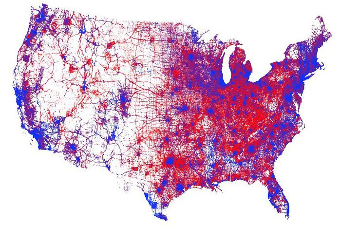
To be clear, that's a 2016 map, so it's not for this election, but we haven't got finalized data yet so such graphics have yet to be produced. The underlying point is still screamingly relevant, though; Republicans like posting geographical county-based maps, because a map with a big county with a comparative handful of voters looks more influential than a densely populated urban county, leading to an image that leans much more favorably in their direction.
Rural voters make up something like 20% of Americans, at best. They're not some giant minority that control the fate of urban America.
And frankly, the Democrats have created policies which would be better for rural Americans than the Republicans' offers. Rural Americans largely don't care; they vote on unrelated factors. Like blind partisanship and ugly racism and misogyny.
-
2020-11-24, 08:49 PM #146Void Lord
- Join Date
- Jun 2010
- Location
- the other
- Posts
- 58,334
He doesn’t have to type what I said twice... it’s not his job to burst the bubble you built for your self. Originally Posted by JohnBrown1917
Edit: Please don’t spam the forum by replying to me, just so people who have me on ignore can see it. Yes, it’s called spam... I don’t care if they see it... I can literally make up what ever I want and they will never repute it... What I choose to say is a testament to why I am on ignore...
Edit 2: I was too late... damn it... saw it coming...
- - - Updated - - -
That’s not what he means... What’s gerrymandering and how is the land structured benefit to the party doing the gerrymandering? Originally Posted by Endus
Last edited by Felya; 2020-11-24 at 08:56 PM.
Folly and fakery have always been with us... but it has never before been as dangerous as it is now, never in history have we been able to afford it less. - Isaac Asimov
Every damn thing you do in this life, you pay for. - Edith Piaf
The party told you to reject the evidence of your eyes and ears. It was their final, most essential command. - Orwell
No amount of belief makes something a fact. - James Randi
-
2020-11-24, 08:53 PM #147Titan
- Join Date
- Jan 2012
- Location
- Chicago
- Posts
- 11,858
oh, well than, having someone on ignore, doesn't block quotes, so here ya go, me backing up my claims. Originally Posted by JohnBrown1917
Originally Posted by Felya
Originally Posted by Felya
Originally Posted by Felya
Originally Posted by Felya
Job done. also added benefit of adding to the growing list of Felya notification number. Originally Posted by Felya
Last edited by beanman12345; 2020-11-24 at 08:55 PM.
-
2020-11-24, 08:53 PM #148Old God

- Join Date
- Jul 2012
- Location
- Shitposter Burn Out
- Posts
- 10,048
Thanks for posting this map, i was looking for it. Originally Posted by Endus
I'm really hating the "conventional wisdom" of not winning the vote of open fields. Or the "conventional wisdom" of not winning rural voters. They erase the fact that Biden overwhelmingly won over Navajo, Hopi, Torono peoples.
Gee why are these people not counted among discussions for rural voters?Government Affiliated Snark
-
2020-11-24, 08:58 PM #149Void Lord
- Join Date
- Jun 2010
- Location
- the other
- Posts
- 58,334
I got infracted for something silly... but, justified... and in my WTF moment, I clicked the post count... it’s all gone... Originally Posted by beanman12345

I get it... I get super defensive about folks on here sometimes. If I didn’t understand the intent, I wouldn’t have realized it might happen. Originally Posted by beanman12345
Last edited by Felya; 2020-11-24 at 09:01 PM.
Folly and fakery have always been with us... but it has never before been as dangerous as it is now, never in history have we been able to afford it less. - Isaac Asimov
Every damn thing you do in this life, you pay for. - Edith Piaf
The party told you to reject the evidence of your eyes and ears. It was their final, most essential command. - Orwell
No amount of belief makes something a fact. - James Randi
-
2020-11-24, 08:59 PM #150Titan
- Join Date
- Jan 2012
- Location
- Chicago
- Posts
- 11,858
Sorry @ felya, but that obvious thing you mentioned, it was too hard to pass up. i'll take the hit for spam if needed.
-
2020-11-24, 09:00 PM #151Void Lord
- Join Date
- Jun 2010
- Location
- the other
- Posts
- 58,334
He is pointing at gerrymandering and the down ballot vote. This isn’t a popular vote argument... Originally Posted by PresidentElectMilchschake
Folly and fakery have always been with us... but it has never before been as dangerous as it is now, never in history have we been able to afford it less. - Isaac Asimov
Every damn thing you do in this life, you pay for. - Edith Piaf
The party told you to reject the evidence of your eyes and ears. It was their final, most essential command. - Orwell
No amount of belief makes something a fact. - James Randi
-
2020-11-24, 09:09 PM #152Old God
- Join Date
- Jul 2012
- Location
- Shitposter Burn Out
- Posts
- 10,048
No, its part of the national pastime "Dems R bad at messaging". They flip between Counties or or Gerrymandering to stoke the clickbait. Originally Posted by Felya
Shit gets old to explain..... GOP friendly media dominates in those regions. Messaging struggles to get through there.Government Affiliated Snark
-
2020-11-24, 09:32 PM #153Elemental Lord

- Join Date
- Aug 2015
- Posts
- 8,718
I don't think it is rural vs. urban. Quite a few rural counties in CA and CO voted overwhelmingly for Biden. Personally it is more a matter of economic opportunity vs. the lack of it. Originally Posted by PresidentElectMilchschake
To address Endus' point, yes land doesn't vote, but having a lot of land allows for easier district gerrymandering to your party advantage. At a state level, where redistricting will be conducted next year, GOP has a major advantage over Democrats. If you go on Twitter, there are already preliminary maps showing how easy it is to convert OH from 14R - 4D to 16R - 2D. The same with FL. Democrats failure to win 2020 at state level and take control of redistricting in 2021 will haunt them for a long time.
Dave Wasserman on Ohio Map.
Florida Map.Last edited by Rasulis; 2020-11-24 at 09:41 PM.
-
2020-11-24, 09:40 PM #154Titan
- Join Date
- Jan 2012
- Location
- Chicago
- Posts
- 11,858
And the Census run by the Trump shitshow administration will only compound this issue in many states. Originally Posted by Rasulis
-
2020-11-24, 10:27 PM #155Elemental Lord
- Join Date
- Aug 2015
- Posts
- 8,718
It does not help. The bottom line is that gerrymandering favors the party with geographic voter support advantage. Those dense urban centers can be sliced and dices in so many ways to neutralize their population size advantage. Here is a perfect example. Cincinnati is split in two, each half paired with a ton of R areas, so that both Cincinnati districts are always Republican. Originally Posted by beanman12345
Last edited by Rasulis; 2020-11-24 at 10:34 PM.
-
2020-11-24, 11:35 PM #156The Undying


- Join Date
- Aug 2008
- Location
- Rigging your election
- Posts
- 36,865
I'm sure we'll see plenty of @Theodarzna in this thread, criticizing every tiny little thing about Biden, including the color of his suit. It's a predictable stark contrast from her complete lack of any criticism for Trump for the last 4 years. Originally Posted by PresidentElectMilchschake
But yes, I find it hilarious that people are already predicting that Biden will drone strike US citizens and cut welfare programs before he's in office. As if they weren't already projecting their egregious biases from the roof tops already, they have to pretend they have a crystal ball to the future of the Biden presidency. And of course, when their predictions don't come true, it will be such delicious egg on their face.2014 Gamergate: "If you want games without hyper sexualized female characters and representation, then learn to code!"
2023: "What's with all these massively successful games with ugly (realistic) women? How could this have happened?!"
-
2020-11-24, 11:44 PM #157Old God

- Join Date
- Nov 2008
- Posts
- 10,440
So how are you guys liking the Biden Bump in the stock market?
Dow 30,000 all credit goes to Biden who's already breaking records.
(see Donny took credit for the stock market the second he won the election, so what comes around)
Buh Byeeeeeeeeeeee !!

-
2020-11-24, 11:56 PM #158Legendary!

- Join Date
- Feb 2010
- Location
- A highly disgruntled constituent of Lindsey Graham.
- Posts
- 6,167
So far I am liking Biden's Cabinet picks a lot. Yelen and Blinken are both excellent picks for their roles. Both are extremely respected, no drama, and capable in their fields. Neither are yes-men(or yes-woman), and both will perform well for the nation with minimal fuss. Both will also sail through senate confirmations with no real issue, expect the usual 90+ votes for them.
Both are essential picks for the nation, because both departments have a LOT of repair work to do, and not much time to do it. SecState is going to be one of the hardest jobs in the world in January, so I hope Blinken can hit the ground running, because we can't wait any longer. I am really interested in the DoJ and EPA picks, but these choices make me feel pretty good about it, so I expect competent and respected experts in those fields as well. DoD will be comparatively easy, which is to say still challenging, but it isn't quite as broken as the state department is.
- - - Updated - - -
Biden will absolutely drone US citizens. It is normalized now, and I don't know what it would take to put that cat back in the bag. I expect an expansion of surveillance operations on US soil as well, and I will absolutely fuss about it when it happens. Biden is a huge improvement over Trump, but every President needs to be held accountable, and I have no intention of providing him the sort of blind loyalty that Trumpsters give their idol. Originally Posted by Cthulhu 2020
-
2020-11-25, 12:36 AM #159Void Lord
- Join Date
- Jun 2010
- Location
- the other
- Posts
- 58,334
Why doesn’t he get his kids and friends jobs? How callous can this man be... Originally Posted by Thekri
Did you hear about his wife? Instead building tennis courts, creating gaudy decorations and faking to give a shit about Christmas... Biden’s wife will keep working... how selfish...Folly and fakery have always been with us... but it has never before been as dangerous as it is now, never in history have we been able to afford it less. - Isaac Asimov
Every damn thing you do in this life, you pay for. - Edith Piaf
The party told you to reject the evidence of your eyes and ears. It was their final, most essential command. - Orwell
No amount of belief makes something a fact. - James Randi
-
2020-11-25, 12:38 AM #160Banned
- Join Date
- Dec 2011
- Location
- Обединени социалистически щати на Америка
- Posts
- 28,394
How does "biden will use drone strike" lead to you people saying he will use them on US citizens? Like that is somehow the problem, and not the innocent lives that are lost in those attacks. Originally Posted by Cthulhu 2020

 Reply With Quote