Dragonflight: Dark Heart Content Update Notes
 Dragonflight: Dark Heart Content Update Notes
 Dont want to takw grove guardians
 Dragonflight: Dark Heart Content Update Notes
 Rank the Dragonflight Dungeons (beyond knee-jerk reactions)
 MMO-Champion


so why can't the map be adjusted to reflect that? The game size of Broken Isles is nearly the size of Panderia.. why can't they make the ISland bigger on the map to reflect that?
looking at the map, Teldrassil is as big as the whole Broken Isles, but the in-game zone is not even as big as one zone in the broken isles..
Can anyone ask blizzard to change the maps.
 Recent Blue Posts
 Recent Forum Posts
-
2016-03-21, 10:52 PM #1Legendary!


- Join Date
- Oct 2008
- Posts
- 6,389
Broken Isles looks much bigger than the map shows...
-
2016-03-21, 10:54 PM #2Immortal

- Join Date
- Aug 2010
- Posts
- 7,505
Because the size of the game world is not accurate to the actual size of the world.
-
2016-03-21, 10:56 PM #3The Lightbringer

- Join Date
- Oct 2008
- Posts
- 3,982
People are already up in arms about them moving the Maelstrom a little to the side to make room for the current Broken Isles (the landmass actually was on the old map, but suuuuper tiny). Originally Posted by Mace

Basically, you gotta suspend your disbelief and come to the compromise that in-game size of the landmass is actually much bigger than what it should be, in comparison to the rest of the landmasses.
-
2016-03-21, 10:56 PM #4Herald of the Titans

- Join Date
- Mar 2010
- Posts
- 2,873
Scaling the game world to the acutal map is probably impossible to do and just a lot of extra work tbh.
Heck, our own maps we use aren't perfectly scaled either.Last edited by babyback; 2016-03-21 at 10:59 PM.
-
2016-03-21, 11:07 PM #5Legendary!
- Join Date
- Oct 2008
- Posts
- 6,389
but what's wrong with having the map bigger in -game? People moaning seems a poor excuse, it wasn't even in the map before and now it is, might as well make it reflect the size of the zone right? Originally Posted by Veyne
i mean isn't broken isles nearly the size of Panderia in-game?
- - - Updated - - -
hmm.. i don't know why it bothers, me it shouldn't, but i like more land mass being shown I guess.
i hate that although the conitnents look so big, they seem so small in-game
i'd like some consistency, i know in-game is not actual size, but i'd like the relative size to be the same.
-
2016-03-21, 11:07 PM #6The Lightbringer
- Join Date
- Feb 2014
- Posts
- 3,163
Pandaria is too big on the map in comparison to the other continents. Originally Posted by Mace
Increasing Broken Isles much further would push the existing continents even further out of place, so it would probably look silly.
Its an artistic map, its not meant to be to scale afterall.
-
2016-03-21, 11:55 PM #7The Insane

- Join Date
- Oct 2009
- Location
- Washington, USA
- Posts
- 16,615
If they wanted to make the map accurate to the in-game scale they'd have to make Kalimdor and the Eastern Kingdoms much larger and Pandaria much smaller as well.
They're the sizes and in the positions they are so they're easy to see and click on without making the map look too smooshed together.
-
2016-03-21, 11:58 PM #8The Insane

- Join Date
- Jun 2010
- Posts
- 16,901
Game regions in lore are not the same as their size in the game. Goldshire has a population of thousands, and isn't literally on Stormwind's doorstep.
The world map art is intentionally not to scale with the game. The minimap, the one you use to actually navigate, is.
-
2016-03-22, 03:07 PM #9Deleted
They should make the isles smaller on the world map actually. The islands are far too big to what we have been shown for years on the lore accurate maps. The ingame mapsize does not need to match the world map 1:1 as wow itself is not as big as it meant to be ingame either.
-
2016-03-22, 07:25 PM #10Legendary!
- Join Date
- Oct 2008
- Posts
- 6,389
but they retconned the old maps, we only feel that it should be small based on the old lore, that's it - but that old lore has been updated ... Legion shows there was much more than just those 3 small islands.. no need to pretend it was nearly correct by making them tiny, might as well just make them big as they are. Originally Posted by Odelius
-
2016-03-22, 07:28 PM #11The Insane
- Join Date
- Oct 2009
- Location
- Washington, USA
- Posts
- 16,615
Actually, the Broken Isles are pretty small in the newest lore map from Warcraft Chronicles as well, which includes all of the Legion zones. Originally Posted by Mace
-
2016-03-22, 07:30 PM #12The Insane


- Join Date
- Aug 2015
- Location
- Base Camp
- Posts
- 19,203
they are isles, they are supposed to be small on the map.

Formerly known as Arafal
-
2016-03-22, 07:47 PM #13Deleted
Professional cartographers will tell you that on a map like this, Pandaria is shown as bigger than it actually is. Projecting a spherical map on a flat pane causes that.
Most maps we are familiar with use Mercator projection that makes countries further from the equator look bigger than they actually are. For example, on Google Maps, Greenland (far from the equator) looks similar in size to Africa (close to the equator), but actually, it's smaller than, say, Brazil.
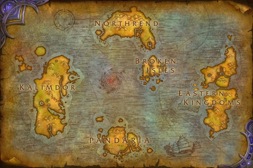
As you can see, pandaria is far from the equator, almost near the south end of the map, while the Broken Isles are REALLY far from the North pole, with Northrend in-between.
-
2016-03-22, 08:01 PM #14Legendary!
- Join Date
- Oct 2008
- Posts
- 6,389
you're making an assumption here.. you're assuming that is the whole planet.. I can assure you it is not. In fact It is my opinion that ALL of this map above is in the northern hemisphere and is the fractured remains of what was a super continent. Originally Posted by nzall
how? well Northrend is at a polar cap - evident by the ice and frigid north -- but as you go south, it doesn't get hottest midway then cooler agian.. no ..it keeps getting hotter, in fact.. the hottest bits are at the tip of the continents - STV in the east - uldum/silithus/tanaris in kalimdor - they are all hottest regions with ecology like a tropical forest (un'goro/STV) unless a disaster has made the land barren (Badlands/Tanarais/Silithus/Uldum) - in Chronicles, Uldum was a lush and very beautifully exotic tropical jungle we are told... it was the efforts to stop Lei-shen that have made it so barren.
That does that mean? What you're seeing is actually just one side of the northern hemisphere of a planet. Pandera is not far from the Equator but pretty much on it -- imo, the Equator is either sitting just under Pandera, or just above it, or crosses it somewhere.. not sure which , but it's that.
- - - Updated - - -
I know.. I think they've made a mistake there.. the point of this post is they should not have bothered to try and make it look small on the map since they were updating the lore anyway. Originally Posted by Rivin
I think they made it look small on the map because of all the retcon QQs that were been thrown. and I don't get it, what's the big deal, it's bigger now anyway, it's a new continent, no need to make it tiny and mess with your consistency, easier to just explain to people, what you saw in WC3, was only part of it, not all of it, it's not like cartographers actually go their on holiday due to the dangers that were there, they didn't realize the extent of the area and be done.
if Broken Isles was rperesented accurately on the in-game map to it's in game area.. it would be much bigger, and that would be fine. I mean wouldn't you be fine with that?
-
2016-03-22, 08:05 PM #15Pit Lord

- Join Date
- Mar 2014
- Location
- US
- Posts
- 2,456
Time Lord technology obviously.
-
2016-03-22, 08:07 PM #16Immortal

- Join Date
- Aug 2013
- Location
- Portugal
- Posts
- 7,677
"Panderia" though. "Panderia".
-
2016-03-22, 08:08 PM #17Legendary!
- Join Date
- Oct 2008
- Posts
- 6,389
not only that, Northrend in game is HUGE - it's too small on the in-game and chronicle map. Originally Posted by Nymrohd
but the Chronicle map is the in-game map right?
if we were drawing the maps to their in-game sizes, what would they look like roughly representative wise/relative wise i wonder.
-
2016-03-22, 08:10 PM #18The Insane
- Join Date
- Oct 2009
- Location
- Washington, USA
- Posts
- 16,615
It's not meant to be a continent though. In-game it's presented at the scale we expect game continents to be, because it needs to be that large for gameplay purposes, but lore-wise it's just a small set of islands. Originally Posted by Mace
-
2016-03-22, 08:41 PM #19Legendary!
- Join Date
- Oct 2008
- Posts
- 6,389
that's a shame, i've wanted them to merge them for quite a while.. especially Quel'thalas and Azure/bloodmyst Originally Posted by Nymrohd
-
2016-03-22, 08:42 PM #20Herald of the Titans

- Join Date
- Aug 2007
- Posts
- 2,571
Because it's a tie-in to the Doctor Who franchise. Originally Posted by Mace

 Reply With Quote